
Chasing their own tails
Sometimes I wonder if the loony Left will ever know what hit them.


I guess gerrymandering is no bueno now? There sure wasn’t an objection to it in certain states four or so years ago.
After what’s gone on in Texas, this is the Left’s plan: do more of what they did after the flawed 2020 Census. Indivisible screeched about this:
We’re not watching politics. We’re watching a power grab.
In the span of a week, Donald Trump and the Republican Party have launched a multi-state campaign to rig congressional maps, erase voters from the census, and weaponize law enforcement against elected officials — all in service of one goal: permanent GOP control of the House.
This isn’t theory. It’s not a warning about what might happen. It’s happening right now — in Texas, in DC, in Indiana, and in every room where power can be manipulated and lines can be redrawn.
Cementing minority rule doesn’t always look like tanks and mobs. Sometimes it looks just like this: illegal censuses, rigged maps,, and corrupted institutions.
You make it sound like permanent GOP control of the House is a bad thing.
But eventually this is the goal:
We are calling on the governors and legislatures in… California, Colorado, New York, Illinois, New Jersey, Washington, Oregon, and Maryland to prepare and publicly commit to a mid-decade redistricting plan if GOP states redraw their maps.
I’m calling on them to eat crap and bark at the moon. After what you did to Maryland (and the other states) you should be ashamed.
I’ll tell you what I’m going to do. I had to refamiliarize myself with Dave’s Redistricting App but I drew a new Maryland map where districts are compact, contiguous and try to respect county lines. (I did this years ago but I have no idea where that map went so I started anew.) For example, one district will be entirely in Montgomery County because that’s populated enough and contiguous. (No grabbing population out of other counties just to dilute Republican strength.) I think Prince George’s County can get the same treatment. The only weakness I see in that program is that it uses existing precincts, so the lines won’t be as defined as I might like.
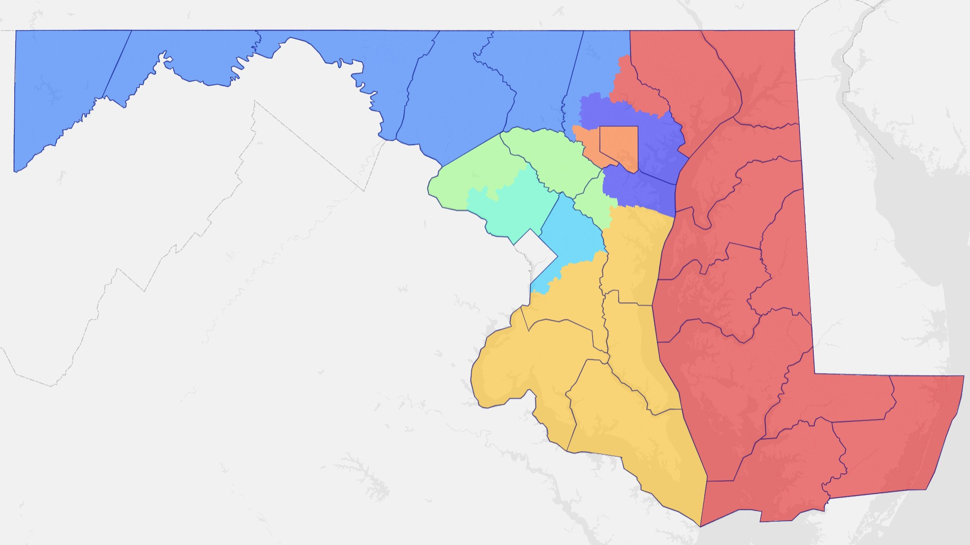
Since most aren’t familiar with Maryland, here’s how the districts are set up.
District 1 (red) - all of the Eastern Shore, Harford County, and a section of eastern Baltimore County.
District 2 (purple) - the eastern end of Baltimore County and some northern suburbs of Baltimore as well as northern Anne Arundel County.
District 3 (green) - Howard County, the western portion of Montgomery County, and the northwestern end of Anne Arundel County.
District 4 (light blue) - the northern portion of Prince George’s County.
District 5 (yellow) - all of Calvert, Charles, and St. Mary’s counties, southern Prince George’s County, and southern Anne Arundel County.
District 6 (blue) - all of Garrett, Allegany, Washington, Frederick, and Carroll counties, plus northwestern Baltimore County.
District 7 (orange) - Baltimore City and close-in western suburbs in Baltimore County.
District 8 (aqua) - the eastern half of Montgomery County.
For the most part I use existing district designations that have been established in Maryland for the last several decades, except the real Third District lies closer to Baltimore City. Now I ring it around the Beltway suburbs.
And all of these came within 1,000 of even population - having to do it by precinct makes it a little less exact.
Redistricting shouldn’t be that hard, but if the Democrats want to shout and scream about the Republicans practicing an art the party of the ass has all but perfected, I’m going to shout right back. It took me about an hour to create the map, and I have no idea what the partisan makeup is. My guess is that it would be a 6-2 D map, somewhat similar to the districts in place during the 2000s.
By the way, it looks like Salisbury is the only game in town for this one so if you’re driving around this afternoon and see a bunch of malcontents bitching about gerrymandering and Trump doing his level best to make Washington, D.C. presentable, go laugh at them for me. Seems like this protest thing is running out of steam, doesn’t it?
In the meantime, though, you can Buy Me a Coffee, since I have a page there now.
The census is used to determine federal voting districts. Local districts are set by local governments, so redrawing the federal districts using a census of eligible federal voters makes sense. The Democrats are, as always, full of crap.
I saw they were in front of the WH yesterday - anywhere else?